Last weekend we had this great idea to head to the arctic circle. It's about 150 miles north of Fairbanks on the Dalton Highway. Alex and I got a really late start thinking that normally 150 miles wouldn't take that long, but we both didn't know that the Dalton Highway is a dirt road that follows the pipeline all the way to the Beaufort Sea!
I'm not sure if anyone knows the t.v. show Ice Road Truckers on the Discovery Channel, but the ice road that the truckers travel on is filmed on the Dalton Highway. We started out in the afternoon thinking we would be back before sun down, as we got further away from town we both realized that this trip would not be doable.
To make it feel as if the whole day was not a waste Alex and I found a trail and went for a hike. We pulled off the highway and turned into the Wickersham Dome Trailhead. These trails are designed for mushers, so we didn't have the time or resources to do any of the full loops (20-30 mile loops and some go out 100 +). We just did an out and back, which was roughly twelve miles round trip. It's really neat, these trails are maintained by BLM and there are cabins along the trail that you can reserve and stay the night. It would be neat to snow shoe or cross country ski in and stay the night. The trails/cabins would be perfect for viewing the aurora borealis.
The whole time walking through these trails I was nervous we would run into a bear or moose. There was a lady and her dogs who we stopped and talked to for awhile. She had her gun and bear spray on her and that didn't calm my nerves!! All we saw though were a ton of moose and caribou tacks, oh and fox poop!
I didn't get a lot of good pictures, it was overcast and really hazy. I tried to get some good ones and here they are.
We took the Summit Trail and made it to the summit:
This would be perfect for viewing the aurora, there is a fire pit and the view goes for miles:
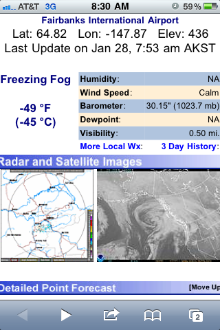
I think I forgot to mention it was cold!! We estimated that it was maybe 38 F, there was snow in the shady spots and the creeks were frozen over:
The only animal we saw was a ptarmigan. They are normally a brown color in the spring/summer months, but during the winter they turn white as snow:
The view from the summit looking toward the arctic circle. The picture doesn't do it justice and I wish the camera wouldn't pick up so much haze, but it was beautiful from the top. There was a cloud bank off in the distance sitting on the Brooks Range and seeing that made the whole trip worth it.
On our way back the sun was starting to set and I snapped this shot:


